"Was a Dangerous Eurotunnel "Pensioned Off" (and if so by whom)?" (Update: British Govt. touts rail service)
Quote: "November 5, 2010 12:48 pm
Canadian funds pay £2.1bn for Channel tunnel link
By Robert Wright, Transport Correspondent
Two Canadian pension funds are to pay a
higher-than-expected £2.1bn for the right to run the UK’s only dedicated
high-speed rail line, in the first significant privatisation of the new
coalition government.
Philip Hammond, transport secretary, described the sale of a 30-year
concession for High Speed One to Borealis Infrastructure and the Ontario
Teachers’ Pension Plan, announced on Friday, as “great news for
taxpayers and rail passengers alike”.
The sale was “a big vote of confidence in UK plc and a big vote of
market confidence in the future of high speed rail”, Mr Hammond said.
“It also shows that the decisive action this government has taken to
reduce the deficit is already paying dividends and that investors
believe once again that Britain is open for business,” he went on.
The Borealis consortium defeated a consortium of Eurotunnel, the Channel tunnel operator, and Goldman Sachs; a consortium led by Germany’s Allianz and a group led by Morgan Stanley to
win the competition, launched in June. Borealis is the infrastructure
arm of Omers Worldwide, one of Canada’s largest pension funds.
“The £2.1bn receipt exceeds the highest expectations for the sale and
will make a welcome contribution to reducing the deficit,” Mr Hammond
said.
The generous valuation of the line is reminiscent of the infrastructure deals at the height of the sector’s boom before the financial crisis, when funds paid unprecedented valuations for toll roads, container ports and airports.
The sale brings to an end a story of government
involvement in the link that dates back to 1998, when the Department for
Transport stepped in to guarantee £3.75bn of LCR’s debt as the
then-private company struggled to fund the line’s £5.6bn construction
costs. It guaranteed future payments from operation of the domestic high-speed services to Kent that were launched in December. The guaranteed future revenues were a significant attraction for bidders, according to people involved in the transaction.
A consortium led by Sir Adrian Montague, the former treasury official, tried to launch a bid for LCR in 2006 but was eventually rebuffed by the then Labour government.
The HS1 sale is the first phase of a restructuring and privatisation
of LCR that has been planned since 2006. The company’s substantial
property holdings around London’s St Pancras station, at Stratford and
at Ebbsfleet in Kent are all expected to be gradually sold off as market
conditions allow. The Department for Transport is likely to retain
LCR’s other asset – its minority stake in Eurostar, the only existing
international train operator from St Pancras – for the foreseeable
future.
Quote: ""Recently, an earthquake occurred along the English Channel
coast, with its epicentre at Folkestone in Kent, at
8.28 a.m. (local time) on 28 April 2007. The local earthquake
magnitude was estimated by the British Geological Survey
as 4.2ML (Walker and Musson, 2007) and no discernible
affect was reported on the sea. However, worryingly, a local
news outlet reported that coastal residents on feeling the
tremor “started rushing out from their houses and on to the
beach for safety” (Kent News, 2007)! This highlights the
need to assess the threat from tsunami and associated hazards
in Britain and, if appropriate, raise public awareness of
the potential hazards."
Geological profile of The Tunnel marked with black line (by self), to indicate possible greatest point of weakness and stress.
Quote: "Geology
Geological profile along the tunnel as constructed. For most of its length the tunnel bores through a chalk marl stratum (layer)*
Successful tunnelling required a sound understanding of the
topography and geology and the selection of the best rock strata through
which to tunnel. The geology generally consists of northeasterly
dipping Cretaceous strata, part of the northern limb of the
Wealden-Boulonnais dome. Characteristics include:
Continuous chalk on the cliffs on either side of the Channel containing no major faulting, as observed by Verstegan in 1698
Four geological strata,
marine sediments laid down 90–100 million years ago; pervious upper and
middle chalk above slightly pervious lower chalk and finally
impermeable Gault Clay. A sandy stratum, glauconitic marl (tortia), is in between the chalk marl and gault clay
A 25–30-metre (82–98 ft) layer of chalk marl (French: craie bleue)
in the lower third of the lower chalk appeared to present the best
tunnelling medium. The chalk has a clay content of 30–40% providing
impermeability to groundwater yet relatively easy excavation with
strength allowing minimal support. Ideally the tunnel would be bored in
the bottom 15 metres (49 ft) of the chalk marl, allowing water inflow
from fractures and joints to be minimised, but above the gault clay that
would increase stress on the tunnel lining and swell and soften when
wet.[46]
On the English side, the strata dip
is less than 5°; on the French side this increases to 20°. Jointing and
faulting are present on both sides. On the English side, only minor
faults of displacement less than 2 metres (7 ft) exist; on the French
side, displacements of up to 15 metres (49 ft) are present owing to the
Quenocs anticlinalfold.
The faults are of limited width, filled with calcite, pyrite and
remoulded clay. The increased dip and faulting restricted the selection
of route on the French side. To avoid confusion, microfossil assemblages
were used to classify the chalk marl. On the French side, particularly
near the coast, the chalk was harder, more brittle and more fractured
than on the English side. This led to the adoption of different
tunnelling techniques on the two sides.[47]
The Quaternary undersea valley Fosse Dangaered, and Castle Hill
landslip at the English portal, caused concerns. Identified by the
1964–65 geophysical survey, the Fosse Dangaered is an infilled valley
system extending 80 metres (262 ft) below the seabed, 500 metres
(1,640 ft) south of the tunnel route in mid-channel. A 1986 survey
showed that a tributary crossed the path of the tunnel, and so the
tunnel route was made as far north and deep as possible. The English
terminal had to be located in the Castle Hill landslip, which consists
of displaced and tipping blocks of lower chalk, glauconitic marl and
gault debris. Thus the area was stabilised by buttressing and inserting
drainage adits.[47]
The service tunnel acted as a pilot tunnel preceding the main tunnels,
so that the geology, areas of crushed rock, and zones of high water
inflow could be predicted. Exploratory probing took place in the service
tunnel, in the form of extensive forward probing, vertical downward
probes and sideways probing.[47]
Surveying
Marine soundings and samplings by Thomé de Gamond were carried out
during 1833–67, establishing the seabed depth at a maximum of 55 metres
(180 ft) and the continuity of geological strata (layers). Surveying
continued over many years, with 166 marine and 70 land-deep boreholes
being drilled and over 4,000-line-kilometres of marine geophysical
survey completed.[48] Surveys were undertaken in 1958–1959, 1964–1965, 1972–1974 and 1986–1988.
The surveying in 1958–59 catered for immersed tube
and bridge designs as well as a bored tunnel, and thus a wide area was
investigated. At this time marine geophysics surveying for engineering
projects was in its infancy, with poor positioning and resolution from
seismic profiling. The 1964–65 surveys concentrated on a northerly route
that left the English coast at Dover harbour; using 70 boreholes, an
area of deeply weathered rock with high permeability was located just south of Dover harbour.[48]
Given the previous survey results and access constraints, a more
southerly route was investigated in the 1972–73 survey and the route was
confirmed to be feasible. Information for the tunnelling project also
came from work before the 1975 cancellation. On the French side at
Sangatte a deep shaft with adits
was made. On the English side at Shakespeare Cliff, the government
allowed 250 metres (820 ft) of 4.5-metre (15 ft) diameter tunnel to be
driven. The actual tunnel alignment, method of excavation and support
were essentially the same as the 1975 attempt. In the 1986–87 survey,
previous findings were reinforced and the nature of the gault clay and
the tunnelling medium (chalk marl that made up 85% of the route) were
investigated. **Geophysical techniques from the oil industry were
employed.[48]" Go to: http://en.wikipedia.org/wiki/Channel_Tunnel
With Apologies I should have backed up my files properly on this subject ("naive much?"), unfortunately The MediaLens Forum on which my initial posts on this subject were recorded is undergoing maintenance at this time and a link to a 2010 geological survey of The Tunnel which was available for purchase from one of the institutes (sorry I don't remember which one -although I know it is not The British Geological Survey, although I will approach them in order to locate the source-), appears to have dis-appeared. Paranoid? Possibly, if anyone else knows where to find it please tweet it to me or post a comment here.
Quote: "Turkey’s New Undersea Tunnel Is Built to Resist Earthquakes
How engineers made a train tunnel that connects two continents
When designing the tunnel, engineers had to take into
account its proximity to the active North Anatolian Fault, which lies
about 10 miles (16 kilometers) away. Activity along this 930-mile
(1,500-kilometer) fault system resulted in a devastating 7.4 magnitude earthquake that struck Turkey in 1999, killing tens of thousands of people.
"The earthquake hazard really drove the design of the project," said Joseph Wartman,
a civil engineering professor at the University of Washington in
Seattle who was not involved with the project but has studied its
progress due to his work on earthquake-resistant design. The tunnel's
engineers had to account for the possibility of earthquakes of
magnitudes as large as 7.5, he said. "It's about as challenging as it
gets for tunnel design."
Earthquake safety determined the sizing of the tunnel and a
lot of the design details, Wartman said. "This project really posed
some significant challenges to the designers. It's really pushing the
boundaries of underground construction in a seismically active area."
Although earthquakes can cause a lot of shaking, that's not
as much of a concern with underground tunnels, Wartman said. "They're
actually some of the safest places to be, because the level of shaking
is lower below the ground compared to the surface." He explained that
this is due to the mechanics by which the seismic waves propagate across
the ground.
"It may not be particularly intuitive that something deep is actually safer, but that's the case in this situation," he said.
Turning Solid Ground Into Liquid
The real concern during an earthquake is a phenomenon known
as liquefaction, which can temporarily soften the soil surrounding the
tunnel, effectively turning that soil into a liquid, Wartman said.
"The soil is no longer supporting the tunnel, it's trying to dislodge
it, and it can actually cause tunnels to float up," he said.
"We have seen many cases where below-ground structures such as gasoline tanks float up to the surface in an earthquake."
Jonathan Stewart,
a civil engineering professor at the University of California, Los
Angeles also pointed to liquefaction as a major concern for the Marmaray
project, especially given the massive liquefaction observed during the
1999 earthquake in Turkey. "That's probably the single biggest
threat," said Stewart, who was not involved with the tunnel's design.
Stewart noted that the North Anatolian Fault is similar to
the San Andreas Fault in California and said similar concerns had to be
addressed when building the Bay Area Rapid Transit (BART) tunnel under
the San Francisco Bay.
But despite similarities with California, the tunnel in
Turkey was far more complicated, said Wartman. "What's unique about this
project is that it has an extreme liquefaction hazard, much higher
than, for example, the tube that runs for the BART system under the San
Francisco Bay." That's a result of the type of soil present and the
severity of the earthquakes that hit the region, he said.
To prevent liquefaction, engineers had to make the soil
around the tunnel more dense*, Wartman said. They did this by drilling
holes into the soil adjacent to the tunnel and injecting grout under
high pressure. "Grout is just concrete without the sand, like a slurry,
and as it enters the soil it will make it denser," he said, explaining
that close to 3,000 grout columns were injected around the tunnel.
"It had seemed like an almost insurmountable problem, but I think this is a pretty effective mitigation measure," he said.
All About Flexibility
Long underwater tunnels are usually built in preconstructed
segments that are then connected with joints, said UCLA's Stewart. The
joints need to have enough flexibility that they won't rupture during
an earthquake, he said.
"If you build the tube as a continuous piece, the
deformation can be too large for the structure to accommodate, and you
can end up with fractures that result in leakage," said Jack Moehle,
an engineering professor at the University of California, Berkeley,
who has spent several years working on the underwater BART tunnel. "So
you build it in segments, and you make sure that each segment is
connected by a flexible joint, so that the deformations can be
accommodated."
The Marmaray tunnel was constructed from 11 sections that were connected with joints.
Underwater construction faces other hazards from
earthquakes, Moehle said. "If the ground is shaking, that can unleash an
underwater landslide," he said, adding that how much of a concern that
is depends on the local geology.
Unforeseen Details and Surface Worries
The Marmaray tunnel engineers had taken a lot of care to
account for earthquake-related issues in their design, said Wartman.
"Based on what we've seen in past earthquakes, I would think it's a
quite safe design," he said.
But Wartman cautioned that any large project could always
have complications. "That would probably be the biggest concern here,
that there are unforeseen details providing some trouble," he said.
"We as engineers try to think through all of these
worst-case scenarios, but there's probably a countless variety of these
details that go into every large project."
The real concern may not be with the underwater tunnel
itself, but instead with the above-ground city, said UCLA's Stewart.
Although the 1999 earthquake was devastating, the brunt of it was borne
by areas farther away from Istanbul, he said. "Because of the fact that
the fault just south of Istanbul did not rupture then, it's probably
under a considerable amount of stress now, and Istanbul is one of the
more at-risk cities in the world for earthquakes," Stewart said.
"We know that the fault is primed and ready to go, and
there's a lot of very vulnerable buildings there," he said. "There's a
potential for a real catastrophe," and if an actual earthquake happens,
the tunnel could well be one of the safest places in the city, he said." Go to:
*Bold text mine Ed. Could liquifaction (or similar "non-impactive" stress), be a problem with regard to The Eurotunnel's structure?
Suspended Tunnelling Quote: "The concept of submerged floating tunnels is based on well-known technology applied to floating bridges and offshore structures, but the construction is mostly similar to that of immersed tunnels:
One way is to build the tube in sections in a dry dock; then float
these to the construction site and sink them into place, while sealed;
and, when the sections are fixed to each other, the seals are broken.
Another possibility is to build the sections unsealed, and after welding
them together, pump the water out.
The ballast
used is calculated so that the structure has approximate hydrostatic
equilibrium (that is, the tunnel is roughly the same overall density as
water), whereas immersed tube tunnels are ballasted more to weight them
down to the sea bed. This, of course, means that a submerged floating
tunnel must be anchored to the ground or to the water surface to keep it
in place (which of these depends on which side of the equilibrium point
the tunnel is).
Submerged floating tubes allow construction of a tunnel in extremely
deep water, where conventional bridges or tunnels are technically
difficult or prohibitively expensive. They would be able to deal with seismic disturbances
and weather events easily (as they have some degree of freedom in
regards to movement), and their structural performance is independent of
length (that is, it can be very long without compromising its stability
and resistance).
On the other hand, they may be vulnerable in regards to anchors or
submarine traffic, which therefore has to be taken in consideration when
building one.
Likely applications include fjords, deep, narrow sea channels, and deep lakes.[3]" Go to http://en.wikipedia.org/wiki/Submerged_floating_tunnel
What concerns me greatly is that at the same time as The Oil Industry's baby was (possibly), pensioned off in 2010 the geological report which was produced ( "pay-per-view" only), appears to have vanished.
I have now located a link to the British Geological Society's report on a prev. thread (I was unable to locate it via any current search engine), the report is still "pay-per-view" only but you will note that it was first published in 1997. I was given to understand that an update had indeed been undertaken, I shall check with the BGS....Go to: http://egsp.lyellcollection.org/content/12/1/327.full.pdf "Eurostar rail stake touted for sale by UK government"
Quote; "An earthquake with a magnitude of 2.9 has been recorded in Hampshire, the British Geological Survey has confirmed.
Postings on social media reported buildings in the Winchester area shaking following a tremor shortly after 18:30 GMT.
A police spokeswoman said no injuries or serious damage had been reported.
Matthew Emery, from South Wonston, near Winchester described the experience as "almost as if Concorde had flown over".
The British Geological Survey (Bgs) reported a tremor at a depth of 3km (1.9miles) at Headbourne Worthy, just north east of Winchester.
BGS
Seismologist David Galloway said the UK experienced about 10 quakes of
such a size each year which were "usually quite widely felt around the
area"..
""the whole bed was visibly shaking" as well as one who said the
earthquake sounded "like a bus" crashing "into the neighbours house at
speed".
Hampshire Constabulary said it had initially received lots
of calls from concerned residents in the Kingsworthy area following
reports of something which "felt like an explosion which shook their
houses".
Residents also took to social media to describe what happened.
Rowland Rees tweeted: "Quake felt in Crawley, Winchester. Whole house shook for a few seconds!"
And Jen Gupta said in a tweet: "Our house in Winchester just shook enough to rattle glasses in the cupboard, accompanied by a boom sound."
Rachel
Cristofoli, in Kings Worthy, said: "Everyone felt it and came outside
to see what was going on. It lasted about 5 seconds, but the houses all
shook from top to bottom."
Brook Ethridge, barmaid at the South
Wonston Social Club, said: "About half past six, I was sitting reading
my book and all the glasses started shaking. It sounded like someone had
driven into the back of the club."
Go to: http://www.bbc.co.uk/news/uk-england-hampshire-31009707
For full article.
 Geological profile of The Tunnel marked with black line (by self), to indicate possible greatest point of weakness and stress.
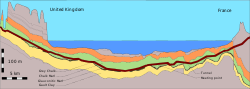
 Geological profile along the tunnel as constructed. For most of its length the tunnel bores through a chalk marl stratum (layer)*
Successful tunnelling required a sound understanding of the
topography and geology and the selection of the best rock strata through
which to tunnel. The geology generally consists of northeasterly
dipping Cretaceous strata, part of the northern limb of the
Wealden-Boulonnais dome. Characteristics include:
Geological profile along the tunnel as constructed. For most of its length the tunnel bores through a chalk marl stratum (layer)*
Successful tunnelling required a sound understanding of the
topography and geology and the selection of the best rock strata through
which to tunnel. The geology generally consists of northeasterly
dipping Cretaceous strata, part of the northern limb of the
Wealden-Boulonnais dome. Characteristics include:


No comments:
Post a Comment